That’s it – the trip is done! After thinking about and planning this trip for the past 10 years, I’ve finally done it. What a great time it was.
I’m back home in Anchorage now. The flights from Los Angeles to Seattle and from Seattle to Anchorage were uneventful, although the flight to Seattle passed right over the western end of Yosemite National Park, so I was able to get some nice photos of Half Dome and El Capitan. I’ve never been to Yosemite, so seeing it from the air was a treat – it would be nice to visit the place sometime.
I can’t believe it’s over. It seems like just a few days ago I was getting off the plane in Oslo to start the ride. It was definitely a trip of a lifetime, and it would be nice to do another long-distance bike tour sometime, somewhere. Of the total distance of 3700 kilometers (2300 miles), I originally figured I would ride about 2575 kilometers (1600 miles). As it is, I ended up riding 2500 kilometers (1550 miles), so I wasn’t too far off my original projection. For comparison, I biked slightly more distance than the plane flight from Seattle to Anchorage, which was 1505 miles. And the flight distance from Los Angeles to Seattle was 1011 miles. I could have ridden the entire distance in the allotted time, but that would have left me with no time to visit along the way, and since the main purpose of the trip was to visit my European friends, I don’t feel too bad about taking a few trains along the way.
Well, this is my last day in Europe. I got up at 6:00 am and got packed and had breakfast in the hotel restaurant. When I carted my boxed up bike through the lobby and out to the shuttle bus, everyone around was staring at it, and me. But maybe it was just because of the way I boxed the bike – completely wrapped in cardboard except for the seat, which stuck up out of the top of the box and served as a nice carrying handle.
.
This is something I've never seen before - chewable toothbrushes. Just another example of how the Europeans are ahead of the U.S. in some ways. This was at the Rome airport. ^
.
I got to the British Airways check-in desk and had my two panniers and bike checked as baggage, but the agent told me I had to get the bike wrapped. For security reasons, at the Rome airport they require that certain large pieces of luggage be wrapped in plastic – it’s the kind of industrial-size plastic wrap that is used to wrap cargo on pallets. So I had to leave my place in the check-in line and go stand in the line for the wrapping. There were two attendants and when they say my bike they looked at each other it was a special thing to get to wrap it, and it looked like they both wanted the job, but one eventually won out. I think he wanted to prove to his buddy how much of an expert he was, so he quickly (and not too carefully) put my bike on the rotating stand and hit the switch. He got about two complete wraps before the bike slipped on the stand and got jammed between the stationary part of the machine and the rotating stand. It put a nice bend in the box, but what happened inside it, I don’t know. I’ll have to wait until I get home to see if something was bent.
.
View of Genova, Italy. My bike route was through the mountains from right to left, to the coast in the center of town, and then along the coast to the bottom left of the photo. ^
.
View of the Rhone Valley in Switzerland, looking toward the northwest. The glacier-covered peaks are the Berner Oberland Alps. The switchbacking road in the lower right corner leads up to Grimselpass. ^
.
Here's a closer view of the road up to Grimselpass. It was a fun ride down from the pass on this road. Location of the road: 46.562850° North, 8.355482° East.^
.
This is the central part of Switzerland, looking west along the Rhone Valley. France is in the distance beyond the snowy peaks. ^
.
The Eiger, with the village of Grindelwald in the cloud-free valley to the right and below the Eiger. ^
.
Somewhere over central Germany. The layout of European villages and farm fields is, I think, more visually appealing than the grid pattern that we have in the U.S. ^
.
As with the flight from Los Angeles to London at the beginning of the trip, today’s flight from London to Los Angeles was in First Class on a British Airways Boeing 747-400. Yesterday when I checked online on the status of the flight I noticed that there were only five other people in First (there are 14 seats total) and that seat 1K was available. The two seats in Row 1 (1A and 1K) are normally reserved for BA’s elite high-mileage passengers or for VIPs, and they are ranked as the best seats on the plane by Seatguru.com. So I was very surprised when the British Airways website offered me the chance to change my seat from 2K to 1K, which I did immediately. And I’m glad I did. Seat 1A was unoccupied which meant that I had about 20% of the entire First Class cabin all to myself! I had a space about 12 feet from side to side and about 7 feet from front to back, with three windows on each side, right up in the very front of the plane. What a way to fly, especially for an 11 hour non-stop flight. I’m sure I’ll never get another deal like that ever again.
.
After a quick 1 hour and 45 minute flight from Rome to London, we landed at Heathrow Airport. Terminal 5, shown here, is British Airways' main terminal for international flights. ^
.
I doubt that I'll ever have another boarding pass like this one. British Airways, Boeing 747-400, First Class, Seat 1K, 11 hours non-stop from London to Los Angeles, all during daytime, with fantastic views of Greenland and the Canadian Arctic. It was the best flight I've ever had. ^
.
My ride from London to Los Angeles. My seat is at the first three windows. ^
.
.
Here's the front of the First Class cabin. There are only two seats in the first row - my seat is on the right, the other one was unoccupied, so I essentially had this entire space to myself. ^
.
British Airways 747-400, Seat 1K. The main seat reclines into a fully flat 6.5 foot long bed. There's a second smaller seat in front where a companion can sit and share dinner on the fold out table that's stored in the console beneath the the windows. ^
.
A person can really get used to the service in First Class. This was the first of two appetizers, followed by the main course, and then dessert, which was then followed by cheese, fruit, and sandwiches. And of course, there was plenty of champagne and wine. ^
.
Appetizer #2 - as described in the British Airways menu, "Twice-baked cheddar souffle with chive pesto and confit of courgette with sage." Does "twice-baked" mean this is just a warmed up leftover? I don't know, but it sure was tasty. ^
.
Main course - "Beef Wellington with brandy, sauteed wild mushrooms and Parmentier potatoes." ^
.
Dessert was "Scottish raspberry mille-feuille with raspberry compote, nougatine, raspberry and balsamic jus." Yummy! ^
.
Unlike the flight from LA to London, which was mostly at night, today’s flight from London to LA is completely during daytime, due to going west instead of east. It was therefore very conducive to sightseeing and I was hoping the pilot would take the great circle route over the southern tip of Greenland, and that it would be clear. It turned out that we went several hundred miles north of the great circle route, which put us on a route over a much wider portion of Greenland. It was completely cloudy over Iceland and to the west toward Greenland, and as we approached the east coast of Greenland the clouds rose in elevation until we were engulfed in the them at 34,000 feet. But fortunately it didn’t last long and I was able to get fantastic views of the western half of the Greenland ice sheet and the outlet glaciers and fjords on the west coast. A bit further on the clouds completely disappeared and I had great views of the glaciers and icecaps on Baffin Island. What a spectacular landscape! But what was hard for me to believe was that everyone else in the First Class cabin had their window shades down. They didn’t give a hoot about seeing one of the most amazing sights on the planet out their windows. How can people be so uninterested in what’s around them? I don’t understand it.
.
What's this? It's a photo of the massive Greenland ice cap. But there's more than just snow and ice in this photo. Near the center of the photo you'll see what looks like a speck of dust on the lens, but it's not a speck of dust - it's the Dye-2 Distant Early Warning (DEW) Line radar station. This is one of 58 long-range radar stations constructed by the United States between 1955 and 1960. The stations were located in Alaska, Canada, Greenland, and Iceland. Their purpose was to provide early warning of Soviet bombers and intercontinental missles launched from the USSR. All DEW line stations have been decommissioned. Dye-2 has subsequently been used as a base for scientific research, including the recovery of deep ice cores for climate studies. Click the photo to get a better view of the station. ^
.
View of the Greenland ice sheet. The blue features are simply meltwater on the surface which form stream channels. The wide, grey-colored features were likely formed by wind acting on, and altering, the structure and/or orientation of the snow crystals. ^
.
A view of supraglacial streams on the Greenland ice sheet. ^
.
Here's a closer view of the previous photo. ^
.
A lake on the Greenland ice sheet. I don't know exactly how big this lake is, but I guess it's probably 300-500 meters long. ^
.
This is near the western edge of the reenland ice sheet, at Evighedsfjord (Fjord of Eternity). The prominent arcuate bands in the glaciers are wave ogives, which typically form at the base of steep icefalls and are quite common on glaciers around the world. ^
.
A closer view of the wave ogives. Location: 66.141552° North, 51.533270° West. ^
.
This glacier is named Kangerlussuatsiaq. It flows southward from the Greenland ice sheet and terminates against an island in Evighedsfjorden. Location: 65.995792° North, 52.836738° West. ^
.
A small alpine glacier in southwest Greenland. The contour-like banding patterns are caused by ablation which has exposed multiple annual accumulation layers in the snow and ice. ^
.
.
View of the glaciers on Baffin Island, Canada. Greenland and the northern Canadian islands are a spectacular landscape. I couldn't believe that everyone else in the First Class cabin had their window shades down. I just don't understand how people can be so dis-interested in the world around them. ^
.
.
The plane arrived in Los Angeles at 6:00 pm and by the time I got through Customs and retrieved my checked baggage it was about 8:00 pm. Since my flight from LA to Anchorage isn’t until tomorrow at 3:30 pm I hopped on the first hotel shuttle bus I saw and ended up at the Holiday Inn near the airport for the night.
This was the last riding day of my trip. I got up a bit earlier than usual and got packed up so that I could do a bit of sightseeing on the way to the airport. I saw the area around, and at, the Vatican. Pretty interesting stuff – there’s a lot to look at. Much more than I had time for. So after a couple hours in the city I proceeded on out to the airport, with a short side trip to the coast to dip my tires in the Mediterranean. It was just a way to finish off the trip, as I dipped my tires in the North Sea in Oslo at the start of the trip.
.
View of the Castel Sant'Angelo. It was built between 135 AD and 139 AD as a tomb for the Roman emperor Hadrian. Throughout the centuries it has served as a mausoleum, Papal fortress, residence, prison, and is currently a museum. ^
.
St. Peter's Square and St. Peter's Basilica. In the center of the square is an ancient Egyptian obelisk that was taken to Rome in 37 AD. In 1586 it was relocated to St. Peter's Square, where it has stood ever since. ^
.
Here's something we don't see in the U.S. - a curb-side gas station. There are many of these small stations throughout Rome. It's a great idea, as they take up very little space and it makes it easy for people to get a quick fill-up. ^
.
In many places, the road to the Rome airport is lined with trees like these. Quite nice. These trees, like many other roadside trees across Germany, Austria, and Switzerland, were cataloged with unique I.D. tags fixed to them. ^
.
Once I got to the airport I checked into my room at the hotel and continued the quest to find a box for my bike. I first went to the baggage check-in area at British Airways to see if they had any bike boxes – no deal, nothing. So the next stop was back at the hotel to see if they had any used boxes I could piece together. Once again, the answer was no. But they did recommend that I go back over to the terminal to the oversize baggage area. The hotel staff assured me that they had bike boxes. So once again, I went back to the terminal, found the oversize baggage area, and was promptly told that they had no boxes and that I should just go buy one. Well duh, if I knew where to buy one, I’d have already done it. And of course they couldn’t suggest a place to buy one. So out of options, I went back to the hotel and rummaged around outside it, looking for dumpsters that might contain some cardboard boxes. Jackpot! As I was dumpster diving for boxes, the hotel security guard approached and asked what I was doing. I explained the situation and he said he had to go call his boss to make sure I could take the boxes. He came back a few minutes later a bit exasperated and said he couldn’t contact his boss and that it was okay for me to take a few boxes. So, after all the trouble of going back and forth between the hotel and the airport terminal, I finally had what I needed. So I spent the next few hours piecing together a box for the bike. Problem solved. I just hope it’s enough to protect the bike during the transfers to four different planes.
.
The final destination of my trip - the Rome airport!
.
Arriving at the Rome airport. Notice the gas station on the right, and in particular the sign displaying the gas prices. Regular unleaded gas is 1.388 Euro per liter. At the current exchange rate, that's US $7.22 per gallon, or 2.5 times more than the current average U.S. gas price. Americans like to complain about our "high gas prices" and how they are a burden on the economy, as if the world's going to come to a crashing halt if the price of gas goes up 2 cents per gallon. But things seem to humming along quite nicely all across Europe. Europeans like their cars just as much as Americans do. ^
.
Statue of Leonardo da Vinci at the entrance to the airport. It's about 25 feet high.
.
Tomorrow I leave Rome at 11:45 am for London. Then it’s an 11 hour non-stop flight to Los Angeles, where I’ll overnight. The next day I’ll finish up with flights from LA, to Seattle, to Anchorage.
.
My bike, inside the pieced-together box that I made for it. Hope it's good enough for the trip home!
Today was devoted primarily to figuring out how to pack up my bike for the plane trip home the day after tomorrow. The most logical thing to do was to find a bike shop here in Rome and buy a bike box from them. But logistically that wouldn’t work because it would be impossible to get a boxed bike on a series of buses and trains from the campground to the airport 50 kilometers away. The next option was to go to the airport and check out the situation in person, so I biked to the central Rome train station and caught a train to the airport. Unfortunately, British Airways and every other airline I checked with apparently does not have bike boxes available. Hard to believe. The person at the British Airways ticket counter told me that it was okay to just remove the wheels, pedals, and handlebars and tape everything up in a tight package. Doesn’t sound like a very good idea to me, as it seems the probability for damage is high. As a last resort I got a hotel room at the airport for tomorrow. I’m hoping the hotel concierge service can assist me in boxing the bike.
.
My tourist shot of the Coliseum. ^
.
After doing what I could at the airport I took the train back into Rome and biked around sightseeing. If you’ve ever wanted to sightsee by bike in Rome, I would strongly recommend against it. I thought the traffic in Genova was bad. Traffic here in Rome is the worst I have ever seen anywhere. There are literally tens of thousands of buses, cars, big trucks, and mopeds, and it seems like they’re all fighting for the same piece of pavement – and usually that piece of pavement is where my bicycle is – with me on it. Traffic rules? Forget it, there are none – none that are enforced anyway. The mopeds are especially problematic. They weave between the crooked lanes of cars and in the bike lane to the front of the line at the intersections, where they all jam together in anticipation of the green light. Then when the light turns green it’s off to the races. The great mass of mopeds all fight to get through the intersection and to be the first through the one (or maybe one and a half) lanes that are not blocked by double-parked cars on the other side of the intersection. Then the cars are right behind them, leaving bicyclists with little choice but to wait for most of the traffic to pass by and then to somehow force their way into the traffic without getting run over. It’s just a crazy, crazy situation and totally outside the realm of experience of pretty much every bicyclist who doesn’t live in Rome. After this experience I’ll never complain about biking in Anchorage again!
.
And another one. ^
.
Anyway, I didn’t get much actual sightseeing done, due to the roads, traffic, and trying to concentrate on my GPS to navigate to where I wanted to go – without getting run over or running into a car, moped, or pedestrian. I was able to get to the Coliseum, and spent a couple hours in that area. But then I needed to get back to the campground before it got dark. Biking in the daytime in Rome is one thing – doing it at night would be absolutely suicidal.
Here are a couple of short videos of the Coliseum and St. Peter’s Square – nothing spectacular, just raw footage. Basically it’s just to say “I was here.”
.
.
.
Tomorrow I’ll ride the final 50 kilometers of my trip to the airport, check into the hotel, and try to get my bike packaged up for the flight home on Saturday.
Yesterday was pretty much the end of the biking portion of my trip. There are still 440 kilometers to go to Rome, and not enough days left to ride it. But that’s pretty much how I figured it would turn out, and I had already planned on taking the train from Genova to Rome, so that’s what I did today – although from Rapallo rather than from Genova.
Italians don’t seem very customer-service oriented. I went to the train station in Rapallo to get a ticket to Rome for myself and my bike. The ticket agent just said gruffly, “No bike. Not possible to Roma. No bike.” and then he handed me a train ticket anyway without any explanation and waved for the next person in line behind me. I walked away shaking my head with a perplexed look, trying to figure out what he had given me. Fortunately, a woman from Holland, who spoke English and had experience with the Italian train system (and with Italians), witnessed the transaction and took pity on me and helped me understand what had just happened. It turned out that the ticket agent was referring to no bikes being allowed on the fast, non-stop express train. He had given me a ticket for the slower regional train which does allow bikes, but he failed to mention that critical fact to me. So all seemed fine after all – I had a ticket for myself and my bike to Rome. Or so I thought. When I got to Rome, the train car that had my bike in it was locked. Before the train agent would unlock the door he asked for my bike ticket. I showed him the ticket the agent had given me in Rapallo and he said it was not for the bike – just me. Turns out the agent in Rapallo didn’t give me a ticket for the bike after all, even though I told him I needed to take the bike on the train. So I had to pay 3 Euros to get the door unlocked so I could get my bike off the train. I suppose it could have been worse.
.
.
I arrived in Rome at 6:00 pm and needed to find a campground to spend the night. Fortunately there was one just 6 kilometers away, on the northeast side of town. Seemed easy enough – until I got out of the train station and into the utter chaos that is everyday traffic in Rome. Imagine the worst traffic that you might have seen in Los Angeles or New York City, and then multiply that by three orders of magnitude – that’s Rome. The streets are not only in a grid pattern, but also include diagonals as well, so the intersections are a combination of roundabouts and signaled intersections, with roads at the signaled intersections often coming from more than four directions, which is not what we’re accustomed to in the U.S. On top of that, there are very few painted lane lines on the streets, so people just drive wherever they want – even on the few centimeters next to the curb where bicyclists are forced to ride. It’s a wild situation all around and it’s a miracle I didn’t get run over on the way to the campground. But I made it safely to the campground and had the usual shower and dinner at the restaurant.
Tomorrow’s plan is to do some sightseeing and figure out how to box up my bike for the flight home.
I got to the Mediterranean Sea today! It was nice to get my fist view of it from about 20 kilometers away while coming out of the hills to the north of Genova. It was a sure sign that my trip is coming to an end soon. But it was nice to see anyway. It was sunny again all day today, which is probably normal for this part of Europe. And it was hot – 32 degrees Celsius, which is something like 90 degrees Fahrenheit – way too hot for this Alaskan.
.
Looking northwest to the Alps, 100 miles away, from the northern side of the mountains along the north coast of Italy. There's fresh snow in the Alps from yesterday's storm. ^
.
During this entire trip I've noticed things that illustrate the differences between Europe and the U.S., particularly with regard to European's increased environmental awareness compared to the U.S. This is a prime example. If this was in the U.S. the trees would be considered a nuisance and would be cut down to make room for cars to park easily. But here in Italy, the trees seem to come first, and they adapt the parking to the trees. It would be great if every U.S. politician and policy-maker did a bicycle trip across Europe. They would then learn how they do things here, and then hopefully take that knowledge back to the U.S. and implement it there. Maybe then the U.S., with 4.5% of the world's population, wouldn't consume 21% of the world's energy. ^
.
Now that's some skillful parking! ^
.
Look at that - the Mediterranean Sea! This was my first view of the Mediterranean, from the mountains 10 miles north of Genova. ^
.
A closer view of the Mediterranean, taken from the same spot as the above photo. ^
.
I rode into Genova at 2:30 pm and straight into another world, transportation-wise. Mopeds are everywhere – thousands and thousands of them. I think they outnumber the cars. And the traffic is nuts – people park everywhere and any way. They don’t always get near the curb and often just get the nose of their car into the parking spot and leave the rest sticking out into the road and strange angles. It’s definitely not the kind of parallel parking that we’re used to in the U.S. Drivers here also double park and cut the road down to one lane with everyone trying to squeeze through the one lane. On top of that, moped drivers weave in and out of traffic, often in the oncoming lane. I saw more than a few near head-on collisions between mopeds and cars. Insane. I quickly came to the conclusion that when riding a bike, you just have to be aggressive and take your part of the road – and hope you survive. Genova’s no place to be timid on a bike!
.
SMART cars are very popular in Europe. As you can see, they don't take up much more room than a bicycle, making them very easy to drive on Europe's often narrow streets, and it's a sure bet you can always find somewhere to park. ^
.
Figurehead of Neptune on Il Galeone Neptune, a replica of a wooden Spanish galleon, in the harbor at Genova. ^
.
The ship Il Galeone Neptune. This is a replica of a Spanish galleon, built in 1983-84. It was used in the 1986 movie Pirates, which starred Walter Matthau as Captain Red. The ship is now permanently moored in Genova and is a tourist attraction.^
.
The superyacht, Radiant, in the harbor at Genova.
.
My original plan was to ride to Genova, stay at a campground for the night, and then take the train to Rome the next day. But I discovered that there are no campgrounds in vicinity of Genova, so I decided to keep riding east another 30 kilometers along the coast to the nearest campground in Rapallo. I can then catch the train from Rapallo to Rome in the morning and be there by 4:30 pm.
.
I noticed that Italians have great tans - and this is why. With almost endless beaches and lots of sun, it's a sunbather's paradise. ^
.
Another beach in Genova. My evening destination is a campground in Rapallo, which is on the other side of the point of land in the background. I'll bike up and over the top through the saddle. ^
.
View of the Mediterranean and the north coast of Italy. ^
.
View of the town of Santa Margherita Ligure, Italy. ^
Today was my longest ride to date on the trip – 174 kilometers, or 108 miles. This was possible because everything went my way today. The first part of the ride was pretty much all downhill from the campground in Aosta to the point where I got out of the mountains and hit the flats of a large agricultural valley between the Alps and the smaller mountains along the Mediterranean coast. In addition to the downhills and flats, throughout the day I had a 20 km/hour tailwind helping me along as well. So the ride was quite enjoyable. And to top it all off, it was sunny all day long and not too hot.
.
The Forte di Bard (Fort of Bard) is situated on a hill overlooking the Dora Baltea River in northern Italy. This has been a strategic military location since about the 5th century. On May 14, 1800, Napolean's army of 40,000 soldiers was held at bay for two weeks by only 400 soldiers at this fort. It ruined his plan for a surprise attack on the Po Valley and Turin, but eventually he overcame the strong defenses of the fort and ordered it destroyed. It was rebuilt in its current configuration in the 1830s. ^
.
View of a small farming village in northern Italy. ^
.
As I was crossing the flat valley I kept looking back at the Alps and the huge cloud bank that covered them from east to west as far as you could see. Apparently the forecast was correct, and there was a significant snowfall over St. Bernard Pass. So I’m really glad I got a ride from Florence to the pass, so that I could cross over the Alps without being delayed. I’m now only about 80 kilometers from the Mediterranean Sea – I’ll be there tomorrow. And I saw the first palm tree today, 90 kilometers from St. Bernard Pass.
.
Looking north back to the Alps. The blanket of clouds stretched from east to west as far as you could see. It's a good thing I passed over the Alps yesterday - it doesn't look like a good day for biking up there today. In the foreground are the cooling towers of a nuclear power plant^
.
There aren’t many campgrounds in this part of Italy, so when I passed by a hotel at 6:30 pm and the nearest campground was still 45 kilometers away, I opted for the hotel. I needed to recharge my camera and GPS batteries anyway, so it seemed like a logical choice. I had an interesting time checking in, which was unexpected because the clerk at the front desk spoke English quite well. I asked him where I could store my bicycle for the night and he somehow thought I meant that I wanted to go to a store. He directed me to a cluster of shops two kilometers away. I tried to explain that I didn’t want to go shopping, but that I needed to put my bike someplace at the hotel for the night. We went around and around for about minutes before he understood, at which point he took me around to the back of the hotel and used his remote to open the garage door. He said I could store my bike in the garage overnight. Great. So I went in, he went back to the front desk, and I locked up my bike. But before I was done, the garage door automatically closed, and there wasn’t a switch inside to open it. Great – I’m locked in the garage. But after a bit of searching I found a service elevator that took me up to a storage room, and then out to the hallway.
.
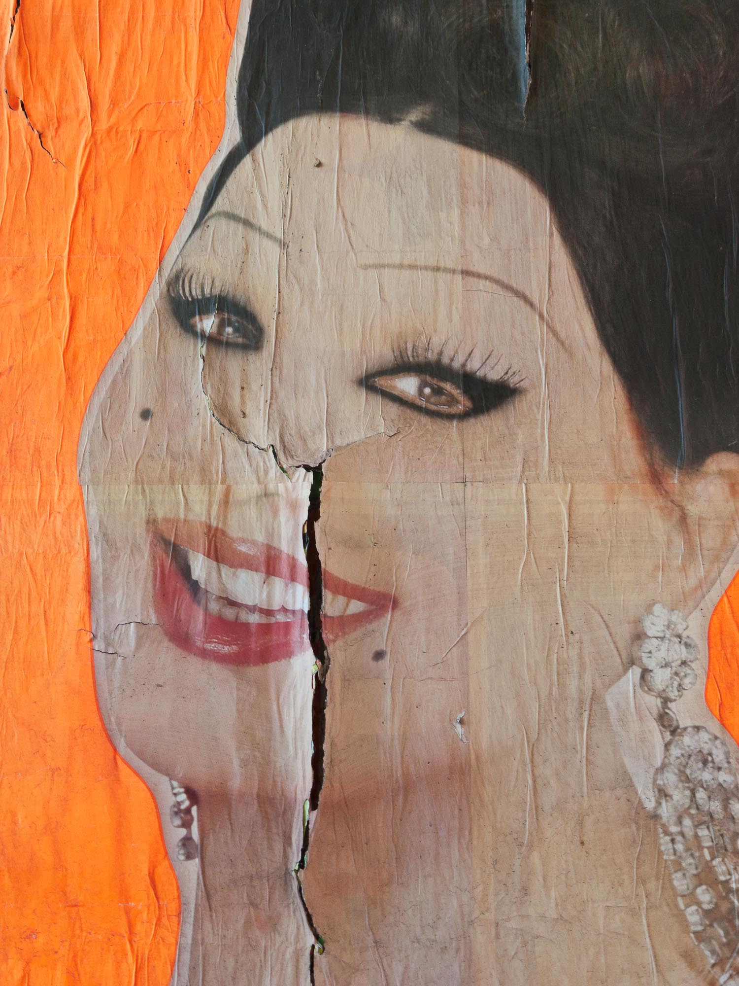
I call this "Cracking a Smile". It's part of a billboard ad for a circus. It was on a concrete wall under a bridge that had been used for numerous other ads. This one was layered on top of at least 10-15 other ads and the layer of paper was so thick that it had started peeling, wrinkling, and cracking. ^
Posted in On the Road on August 30, 2010 by Scott McGee
Sorry that I haven’t posted any updates for the past week. I’ve been in the southwest part of Switzerland visiting Florence Vaudan and she doesn’t have an Internet connection. I’m now (August 30) in northern Italy and will be in Rome in a few days. When I get a chance (and another connection to the Net) I’ll post more daily updates from August 22 to the present.
I have however, posted my daily route maps up to the present (August 30) on the Current Location page. Take a look there if you’d like to see where I’ve been.
View of the vineyards in the Lavaux region of Switzerland, on the north side of Lake Geneva. This has been an important wine producing area since the 10th century. ^
.
This is Day 6 since I first arrived at Florence’s place and it’s getting to be time to head south to Italy. But before I get back on the bike, we’re all going to do some sightseeing around Lake Geneva and Lausanne today. Our first stop was the Lavaux vineyards. This is an area on the north side of the lake, with south-facing slopes, that has been one of Switzerland’s principal wine producing areas since the 10th Century. It’s also a UNESCO World Heritage Site. We drove around, stopping periodically to take photos of grapes on the vines and the scenery (and to taste a few grapes – but just a few!). We eventually made our way to Lausanne and took a walk along the lake front, ending up at a place where you can rent paddle boats. We got one for an hour, with Florence and Jenny providing the propulsion, while I sat in the back and enjoyed not having to pedal. There was a sign on the boat indicating a dangerous area where the large lake ferries approach and depart, and it said in bold red letters, “Danger Zone”. But somehow our two drivers neglected to see the sign until we were in it. But the sign didn’t say to stay out of the danger zone, so we took canvas top off the boat and just relaxed in the sunshine, bobbing in the waves. A bit later it started getting crowded with other paddle boats so we headed back, as our hour’s time was up anyway.
.
The Lavaux region stretches across the northern side of Lake Geneva. These grapes will be ready to harvest in a couple of weeks. ^
.
After Lausanne, we drove back to Martigny and then up to the Grand Saint Bernard Pass, on the border between Switzerland and Italy, and at an elevation of about 8,100 feet. I originally was planning to bike up to the pass, but that would have meant that I’d do it tomorrow, and the weather forecast was calling for 6-8 inches of new snow – not conducive to safe biking. Instead, I’ve decided to just ride down into Italy from the top of the pass today. So once we got to the pass, I unloaded my bike from the car and packed my gear, said my goodbyes to Florence and Jenny, and headed on down the road into Italy.
.
View of the road to Great Saint Bernard Pass, which is one of the highest road passes across the Alps. ^
.
This view, from the Italian side of the pass, looks north to the hospice founded in 1049 by Saint Bernard of Menthon. This pass has been a strategic crossing point over the Alps for the past 2,000 years. Amazing. ^
.
It was a fast 45 kilometer ride – all downhill – to the town of Aosta, where I found a nice campground for the night. Dinner was at the campground’s restaurant, and was a 12” authentic Italian pizza, loaded with toppings on a very thin, crispy crust. Now that’s the way pizza’s supposed to be – not like the stuff we get in the States! Very tasty.
.
View of the mountains on the south (Italian) side of St. Bernard Pass. ^
.
In 1964, a tunnel was opened that passed through the mountains 2,000 feet below St. Bernard Pass. While the road over the pass is open only during the summer months, the tunnel is open year-round and is now the primary route for the shipment of goods through this part of the Alps. This photo shows the road and tunnel entrance on the south, Italian side of the pass. ^
The picturesque little village of Le Chable, Switzerland as seen from the lift up to Verbier.
.
Not much going on today. The place we’re (Jenny and I) are staying at is a rental property that belongs to one of Florence’s friends. They rent it out to tourists, but it was empty this week, so Florence arranged with them to let us stay here for free – pretty good deal. But the owners have tourists coming in today which means that we have to clean up the place and vacate by Noon.
.
Another view of Le Chable, from a bit higher up on the lift.
.
Verbier is one of the more famous ski resort towns in Switzerland. It's situated about 685 meters (2250 feet) above Le Chable, in the valley bottom. This is the road leading up to Verbier.
.
This being the weekend, Florence didn’t have to work, so the plan was to go do some sightseeing in the area around Le Chable. On the way there, Florence got a call from her Mom requesting help at her brother’s restaurant for a catered lunch party. The three of us dropped in for a bit and Florence served us some very good Swiss white wine that was produced in the local area. I can’t remember the name of it, but I’d sure like to find a way to buy a few bottles of it and have it shipped to Alaska. While Florence was helping with the lunch party, Jenny and I took the tram up to Verbier for an afternoon of sightseeing. Verbier is a ski resort town situated about 2,200 feet above Le Chable. Florence came up to join us around 4:30 pm and we all went to her family’s mountain house up above Verbier for the night. It’s a typical chalet-type house with an open floor plan and a sleeping loft upstairs, all with fantastic views of Verbier, Le Chable and the other villages down in the valley, and the mountains all around – very nice place.
.
Hey buddy, wanna buy a watch? Being an upscale ski resort, Verbier has its share of upscale shopping opportunities. This was the most expensive watch I saw while window browsing. That's 9,950 Swiss Francs, which is about 10,300 U.S. Dollars. Interestingly, this watch was more expensive than several nearby diamond-studded gold Rolex watches.